WindRose PRO Help
by Enviroware srl
KML
The KML button allows to export the wind rose in KML format, which can be loaded in Google Earth (http://earth.google.com).
Note than only wind roses can be exported in KML format, not other types of plot.
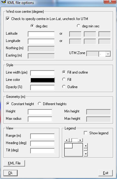
After clicking the KML button, the form for setting the KML options will appear.
The user must specify the coordinates (longitude and latitude) of the centre of the wind rose. Longitude is positive along East; Latitude is positive in the Northern hemisphere.
Alternatively the user may specify the wind rose centre in UTM coordinates. In this case also the UTM zone and letter are needed.
It is possible to select the style of the wind rose: the colors will be those selected in the Options form, but is is possible to specify the color and the width of the lines and the percentage of opacity (0 means fully transparent and 100 means fully opaque).
The wind rose can be represented with a non negative constant height, or as a piramid specifying a minimum height and a maximum height.
The view options can be also specified by the user:
It is also possible to plot a legend over the plot and to specify its position.
Please note that if you copy the kml file in another directory, you must copy the legend file in the same directory, otherwise you get an error trying to view the plot in Google Earth. The legend file is a BMP with the same name of the KML file.
The KML file can be exported in any existing directory selected by the user and with any name.
Note than only wind roses can be exported in KML format, not other types of plot.
After clicking the KML button, the form for setting the KML options will appear.
The user must specify the coordinates (longitude and latitude) of the centre of the wind rose. Longitude is positive along East; Latitude is positive in the Northern hemisphere.
Alternatively the user may specify the wind rose centre in UTM coordinates. In this case also the UTM zone and letter are needed.
It is possible to select the style of the wind rose: the colors will be those selected in the Options form, but is is possible to specify the color and the width of the lines and the percentage of opacity (0 means fully transparent and 100 means fully opaque).
The wind rose can be represented with a non negative constant height, or as a piramid specifying a minimum height and a maximum height.
The view options can be also specified by the user:
- - Range determines the altitude of the eye point (m)
- - Tilt indicates the angle of the eyepoint to the designated point (deg) [0 from the vertical; 90 laterally]
- - Heading describes the angular distance along the horizon to the viewpoint; it is measured from north. 90 shows a heading due west.
It is also possible to plot a legend over the plot and to specify its position.
Please note that if you copy the kml file in another directory, you must copy the legend file in the same directory, otherwise you get an error trying to view the plot in Google Earth. The legend file is a BMP with the same name of the KML file.
The KML file can be exported in any existing directory selected by the user and with any name.
Introduction:
Basics:
- System requirements
- Installation
- License agreement
- Ordering information
- Download
- Evaluation
- Registration
- Support and questions
- Technical warranty
Tutorial:
- Graphical interface
- Load
- Comma separated values
- Excel files
- AERMOD files
- ISC3ST files
- ASCII files
- EnergyPlus Weather
- Frequencies
- Analyse
- Draw
- Chart
- Copy
- Output
- Excel
- DXF
- KML
- SHP
- Save
- Options
- About
- Help
- Quit
- Check for updates